

Plot listing images: how to show boundaries and a possible house
Plot listing images are made in two different ways, and the two are often confused. Either boundaries and a possible house are marked onto an existing overhead view, or the views are built up in 3D. The difference is not a technical detail: it decides how many images you get, from where and in which season they are seen, and what you need to send us. Here is both, shown through three real jobs.
Editing an existing image: the frame stays the same
The base image can be a drone photo you already have, an older shot, or a public orthophoto from the national mapping agency. Boundaries and areas are marked onto it, and a possible layout can be added. The overhead view, the light and the season stay as they are; only what is missing gets added.
Boundaries and area
The quickest addition, and it works even when no photo of the plot has ever been taken. The image below was built from a public orthophoto: plot boundaries and areas were drawn onto it and the image itself was cleaned up for listing use. A buyer sees at a glance where the land starts and ends and how the parcels sit next to each other. In our experience the enquiries get more specific too, because people ask about a particular plot rather than about the field in general.

The boundary line is drawn from whatever you send us, whether a plot sketch, a subdivision plan or open cadastral data, and the image carries a note that it is illustrative. It is a listing illustration, not a survey; an official boundary survey remains a separate, formal procedure.
A possible house
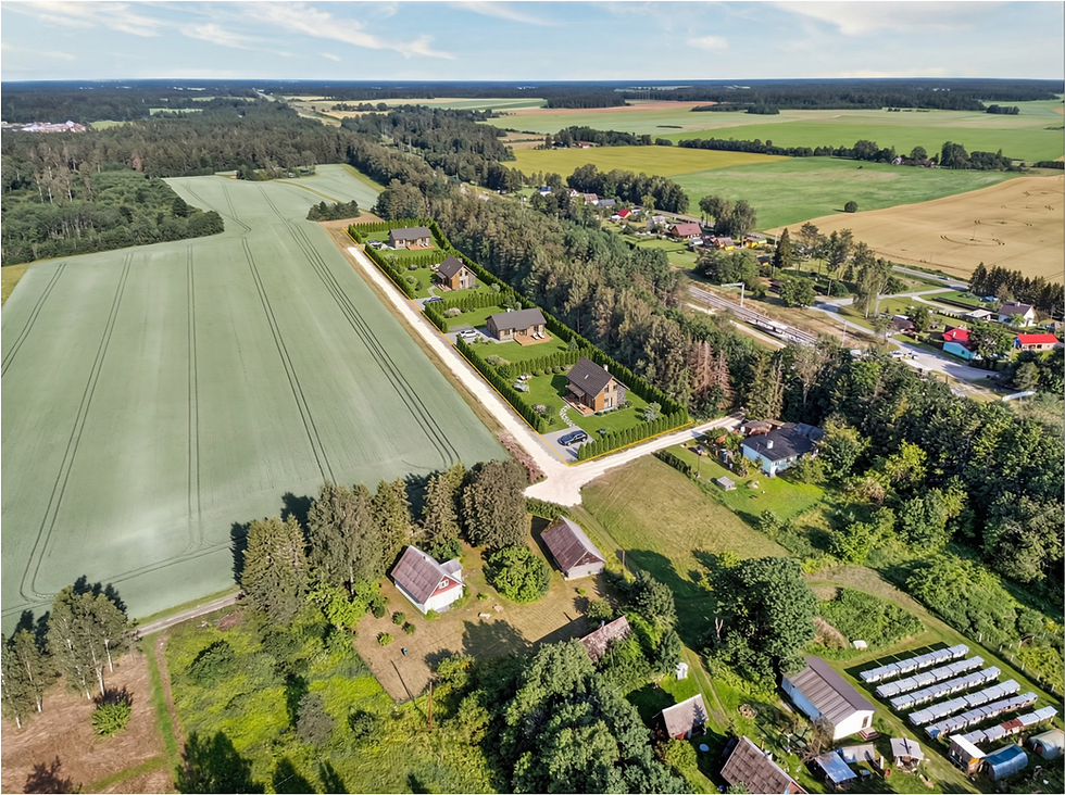
Boundaries show size, but not life. In this case the client did have a drone photo: a winter frame of a completely empty plot. They told us two things, namely where the building area sits on the plot and that a small sauna could go by the river. The rest was our suggestion: the style of the house, the outbuilding, the terrace and the driveway.


Same frame and same light; only the buildings have been added. The same job also produced a wider view with the sauna, the playground and the forest edge, which is the cover image of this article. The listing carries a note that the buildings are illustrative: the reader is being shown what the plot allows, not a finished or promised house.
3D views: the frame is built
An overhead view answers the question of how big the land is. But if you want to show what the place looks like from ground level, or how the sunset comes in across the water, there is nothing left to edit on an existing image, because that frame simply does not exist. Then the views are built up as 3D work. For one plot, everything we received was an orthophoto with a single red line drawn on it: the planned access road. From that one image we produced an overhead view of the whole property, angled views with buildings, and an evening view from the water towards the shore.

The practical difference is this: because no frame is given, views can be made from as many angles as the listing needs, in another season or at another time of day. Either way a public orthophoto works as source material, and in most countries it can be viewed online free of charge. So even when no picture of the plot has ever been taken, a listing image can still be made.
Which one to order?
Decide by what the image has to show. If an overhead view is enough, meaning boundaries, area and one layout, then editing an existing image is the faster and cheaper route. If you want ground-level views, several angles, another season or a more detailed layout, Plot and development site visualization is the better choice. Two real examples: views of a riverside plot and a subdivision prepared for sale.
What to send us
A photo or the cadastral reference. An existing drone photo works, or just the cadastral reference, because we will find the orthophoto and boundary data ourselves.
A plot sketch, subdivision plan or site plan, if you have one. This is what the boundaries and the building area are drawn from. It is not compulsory.
A few lines on what the image has to show. Boundaries, a possible house, the access road or the surroundings, since that decides which type of work is needed and how many images.
Frequently asked questions
Does the drone photo have to be professional?
No, and often no drone photo is needed at all. A simple drone shot or an older photo works if the quality allows editing, and if there is no photo at all we work from a public orthophoto.
Are the boundaries on the image officially accurate?
The boundary line is drawn from the sketch, subdivision plan or open cadastral data you send us, and it is meant as a listing illustration, not a survey. An official boundary survey is a separate, formal procedure.
Does an illustrative house mislead the buyer?
That is exactly why the image and the listing carry a note that the buildings are illustrative. It is then clear that what is shown is what the plot allows, not a finished or promised building.
If you have a plot going on the market, send us a photo or just the cadastral reference and a few lines about what you are selling. We will look at the material and send you a free quote.


Comments